The word ‘bank’ refers to different structures in different fields of geography. For instance, in limnology (the study of inland waters), bank means the terrain alongside the bed of a stream or river. In freshwater ecology, bank denotes the location of riparian habitats. In navigation, the term refers either to a barrier island or a submerged plateau such as an ocean bank.
A barrier island is a long narrow island composed of sand and it forms a barrier between a lagoon and the ocean. A submerged plateau is a flat-topped elevation of the sea floor at shallow depth, say less than 200 metres. An ocean bank, also called a fishing bank or simply bank, is a part of the seabed that is shallow compared to its surrounding area, such as a shoal, or the top of an underwater hill. A shoal is a natural submerged ridge, or bank or bar that consists of sand and other unconsolidated material. It rises from the bed of a water body close to the surface or above it.
To sum up, a bank is an underwater landform. When nutrient-rich currents wash a bank continuously, it can become a fertile fishing ground. There are some twenty large banks in the world such as the Grand Banks of Newfoundland (280,000 sq.km), Agulhas Bank (116,000 sq.km), Dogger Bank (17,600 sq.km), Cleaver Bank (1235 sq.km) and so on.
The Dogger Bank is a large sandbank in a shallow part of the North Sea about 100 kilometres (55 nautical miles) off the east coast of England. It was named after the ‘doggers,’ medieval Dutch fishing boats used for catching cod. This name was recorded as early as in the mid-17th century. It is an important fishing area where large quantities of cod and herring are caught.
South of the Dogger Bank is the Cleaver Bank, a sandbank in the North Sea about 160 kilometres off the west coast of the Netherlands. The surface of the bank consists of gravel and larger cobbles. Since the gravel does not have much silt and has greater transparency, there is enough light to facilitate the growth of calcareous red algae, sea anemones, polyps and so forth. In 2001, the Dutch government planned to mine gravel from the Cleaver Bank but later gave up following adverse environmental impact assessments.
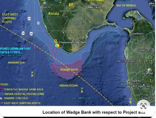
Just like the above banks, the Wadge Bank is a vast oceanic area located south of Kanyakumari (Cape Comorin) in India. The area has been defined by the Fisheries Survey of India (FSI) as that part of the sea bed between latitudes 7°10 and 8°00’N and longitudes 76°40’E and 78°00’E.
Marine biologists had discovered an important fishing ground lying off the apex of the Indian peninsula and named it the ‘Cape Comorin Bank.’ But the Ceylon Fisheries Department later named it as the ‘Wadge Bank.’
Covering an area of roughly 10,000 sq.kms., this submarine plateau is rich in biodiversity and considered to be India’s richest fishery resource. The Wadge Bank waters are moderate in their temperature (26 to 29C). The physical features such as underwater current, tides and waves have less impact on the fishes and aquatic animals of the region, more than 200 species of fish and some 60 other oceanic animals choose this region for feeding and breeding purposes.
According to one estimate, Tamil Nadu has 1,283,751 people engaged in fisheries, aquaculture, and allied activities, and Kerala has a population of around 11.33 lakh fisherfolks, with over 2 lakh being active fishermen.
Most of them depend on the Wadge Bank for their fish catch, livelihood and development. Crores of people in southern India depend on this ‘seafood basket’ for their food security and nutrition security.
The Wadge Bank was under the control of Sri Lanka. When India acceded Kachatheevu, a small barren and uninhabited island off the coast of Tamil Nadu, to Sri Lanka in 1974, both India and Sri Lanka signed an agreement on the maritime boundary in the Gulf of Mannar and the Bay of Bengal on March 23, 1976. That agreement recognised the Wadge Bank as part of India’s exclusive economic zone, and granted India sovereign rights over the area and its resources.
In late 2023, the Indian Ministry of Petroleum and Natural Gas (MOPNG) invited Notice Inviting Offers (NIO) under the Hydrocarbon Exploration and Licensing Policy (HELP) for the exploration of oil and natural gas in three blocks south of Cape Comorin covering an area of some 27,154.80 sq.kms. The Wadge Bank is situated right in the middle of this area. ONGC and Vedanta Corporation are said to have been given license to extract oil and natural gas in these three blocks besides other areas near Chennai and elsewhere.
If this project indeed goes through, it could spell disaster for the Wadge Bank. For instance, oil could contaminate plankton, coral reefs, small fish, crustaceans, and larvae, and make its way up the food chain of marine life. Petrochemicals can have long-lasting effect on the health of marine animals damaging their immune and reproductive systems. The oil exploration activities and oil spills can cause disruption of their migratory pathways and degradation of their habitats.
The technology that is being used to locate oil and gas beneath the ocean floor can be highly disruptive to marine life. The blasts, explosions and usage of heavy equipment can be loud and deafening and severely disrupt the life of marine lives. For instance, whales and dolphins use delicate sounds to find their way around, to find food, and to communicate with each other. These poor animals would be deafened and frightened by the noise pollution.
To put it all tersely, the Wadge bank is an invaluable treasure trove for the fisherfolks and the larger communities of Tamil Nadu and Kerala and crores of people depend on the Wadge Bank for food security, nutrition security, sustenance and growth. Oil and gas extraction in this delicate and sensitive area may bring bloom for the Corporates but doom for the ordinary people. Which side are you on?
References:
[1] S. Lazarus, “Potential Threat to India’s Largest Fishery Resource, ‘Wadge Bank’ Due to Proposed Oil Drilling,” Nagercoil, Tamil Nadu: Institute for Environmental Research and Social Education, 2024.
[2] Various websites.